Login required to started new threads

Login required to post replies

Prev Next
Re: Platypus Thread: Aero Virtual Elevation Testing Protocol [kikopi77] [ In reply to ]
Quote | Reply
kikopi77 wrote:
Thanks v. much guys, I went back to the track today and later on I could tilt the VE using the slider, perfect!

I just forgot to press the 'laps' when riding so I couldn't split the ride on GC, but next time I'll get it all right!

Cheers

You can of course add laps to your file after the fact very easily and then split the file, of course that doesn't help you if it isn't apparent from the file where you want the laps to start end end.
Quote Reply
Re: Platypus Thread: Aero Virtual Elevation Testing Protocol [tttiltheend] [ In reply to ]
Quote | Reply
How can I add the laps?? I know exactly where they start!
Quote Reply
Re: Platypus Thread: Aero Virtual Elevation Testing Protocol [kikopi77] [ In reply to ]
Quote | Reply
Easy peasy. Just drag over the desired part of your ride to make a selection, and then Activity>Save Ride.
Quote Reply
Re: Platypus Thread: Aero Virtual Elevation Testing Protocol [tttiltheend] [ In reply to ]
Quote | Reply
Quote:
Easy peasy. Just drag over the desired part of your ride to make a selection, and then Activity>Save Ride.

Brilliant, worked perfectly!!
Quote Reply
Re: Platypus Thread: Aero Virtual Elevation Testing Protocol [AndyF] [ In reply to ]
Quote | Reply
So if I understand correctly you need to have the true elevation profile to compare to the VE line if you want to tease out the CRR from the CDA. What I can't figure out is how you get the true elevation line into the graph. I'm using GC version 3.1, but none of my graphs have ever had the elevation (green line) do anything. If I turn on constant elevation it will give me a straight line at 0 feet, but other than that I can't figure out how to make it track anything other than VE. I have tried doing runs with the GPS on and off for my test runs, when GPS is on there are lat/long coordinates at each data point but no elevation data. Interestingly, all the group rides I've done on my road bike (only 3 sadly) have altitude data, despite the fact that they use the same Powertap and Garmin 310 head unit with identical settings. The only thing I could think that is different is that I don't have a Garmin speed/cadence sensor on my road bike, so somehow when that is present then altitude data is not recorded? However that hasn't held up either, as I have one ride on my Tri bike without the GSC10 and it still doesn't have altitude (GPS on, lat/long data present); however that ride was recorded as the middle leg of a multi-sport activity so maybe it flushes that data out in the upload??

Any input on this would be appreciated, I know there must be a way to input altitude data after the fact since I see that data in all the screen shots and everyone says they turn GPS off to get clean data. Also, is google earth elevation data reliable or should I be able to find some other source that is usable for this purpose?

Powertap / Cycleops / Saris
Quote Reply
Re: Platypus Thread: Aero Virtual Elevation Testing Protocol [Tulkas] [ In reply to ]
Quote | Reply
Tulkas wrote:
So if I understand correctly you need to have the true elevation profile to compare to the VE line if you want to tease out the CRR from the CDA.

Not exactly, but that's the easiest way. (The harder way involves many tests over the same course where you vary speed over sub-segments of the course). In fact, all you really need is the elevation difference between known points on the course: if you happen to pass by topographic benchmarks with known altitude, you can use that to match the overall profile
Quote:

What I can't figure out is how you get the true elevation line into the graph. [..] Interestingly, all the group rides I've done on my road bike (only 3 sadly) have altitude data, despite the fact that they use the same Powertap and Garmin 310 head unit with identical settings.

That is interesting. However, the 310 doesn't have a barometric altimeter -- it uses GPS to estimate altitude, so the elevation trace you get from it probably won't work for you anyway even if you had it.

If you really, really, want to separate CdA and Crr, you'll either have to do the multiple replicate tests, or you can look up known elevations at a couple or few points of your course.

Or, you could blow that off, assume a reasonable value for Crr, and just look at changes in CdA. That's what many (most?) people do.
Last edited by: RChung: May 2, 15 10:12
Quote Reply
Re: Platypus Thread: Aero Virtual Elevation Testing Protocol [RChung] [ In reply to ]
Quote | Reply
I can understand wanting to estimate CdA and Crr simultaneously. I tend to run different front wheels with different tires and thought I should add that to my testing protocol. I wrote some custom code to implement the VE formulas and tried adding a fancy solver. It appears the equations don't necessarily have a unique solution, so the resulting VE profiles were crazy.

I never had much luck finding the combination a good testing course and decent elevation data, so I would also suggest using the available Crr estimates and just focusing on CdA. If you get really good at estimating CdA, then you might consider adding Crr. I just found it too much to do all at once.
Quote Reply
Re: Platypus Thread: Aero Virtual Elevation Testing Protocol [grumpier.mike] [ In reply to ]
Quote | Reply
grumpier.mike wrote:
I can understand wanting to estimate CdA and Crr simultaneously. I tend to run different front wheels with different tires and thought I should add that to my testing protocol. I wrote some custom code to implement the VE formulas and tried adding a fancy solver. It appears the equations don't necessarily have a unique solution, so the resulting VE profiles were crazy.

I never had much luck finding the combination a good testing course and decent elevation data, so I would also suggest using the available Crr estimates and just focusing on CdA. If you get really good at estimating CdA, then you might consider adding Crr. I just found it too much to do all at once.

If performing comparisons between sets up involves a wheel change, make sure speed measurement of each is taken from the unchanged wheel.

As Robert says, the analysis readily determines which set up provides for the lowest total resistance forces, but not necessarily answers the question as to why. To do that with these methods require more data (i.e. more time spent collecting it for each set up).

There are other reliably repeatable means to measure relative differences in Crr (e.g. roller test protocols), you can use those to adjust for any possible differences from field testing to tease out actual relative contribution of Crr and CdA changes.

http://www.cyclecoach.com
http://www.aerocoach.com.au
Quote Reply
Re: Platypus Thread: Aero Virtual Elevation Testing Protocol [AndyF] [ In reply to ]
Quote | Reply
Been a little while since I did field testing, but I decided recently to give it another go over the weekend with a slightly new setup and had a couple of minor questions for others doing this stuff. In the past, I was either doing the tests with a powertap, which gave both power and built in speed via wheel rotations (definitely don't want GPS!), or with a quarq and using a GSC-10. I hate the GSC-10. I don't normally ride with it on my bike, it is finicky to setup (lots of weird random drops destroying runs, etc). The setup I used over the weekend was a quarq for power and a new garmin hub mounted speed sensor. The new speed sensor was really great: super easy to mount even when I don't want to ride with it all the time, gave good data, etc.

Ok, so now comes the question part. I did a series of halfpipe A/B/A/B runs, using my head unit's "lap" function for identifying each run. I then loaded the ride into goldencheetah 3.1.0 and brought up aerolab. What I found was that trying to determine the CdA for each lap was a bit annoying and labor intensive. The "Estimate CdA and Crr" wants to do it for the whole ride (I think). I could click on a lap and zoom to the lap and then adjust things till it looked right, but that took a lot of time and was a bit error prone and subject to some user bias/interpretation. I even ended up removing the altitude data to get a horizontal line I could use as a guide. Here is an example of doing that below. Is there some better way to do this? Should I split each run into its own ride?


Quote Reply
Re: Platypus Thread: Aero Virtual Elevation Testing Protocol [AndyF] [ In reply to ]
Quote | Reply
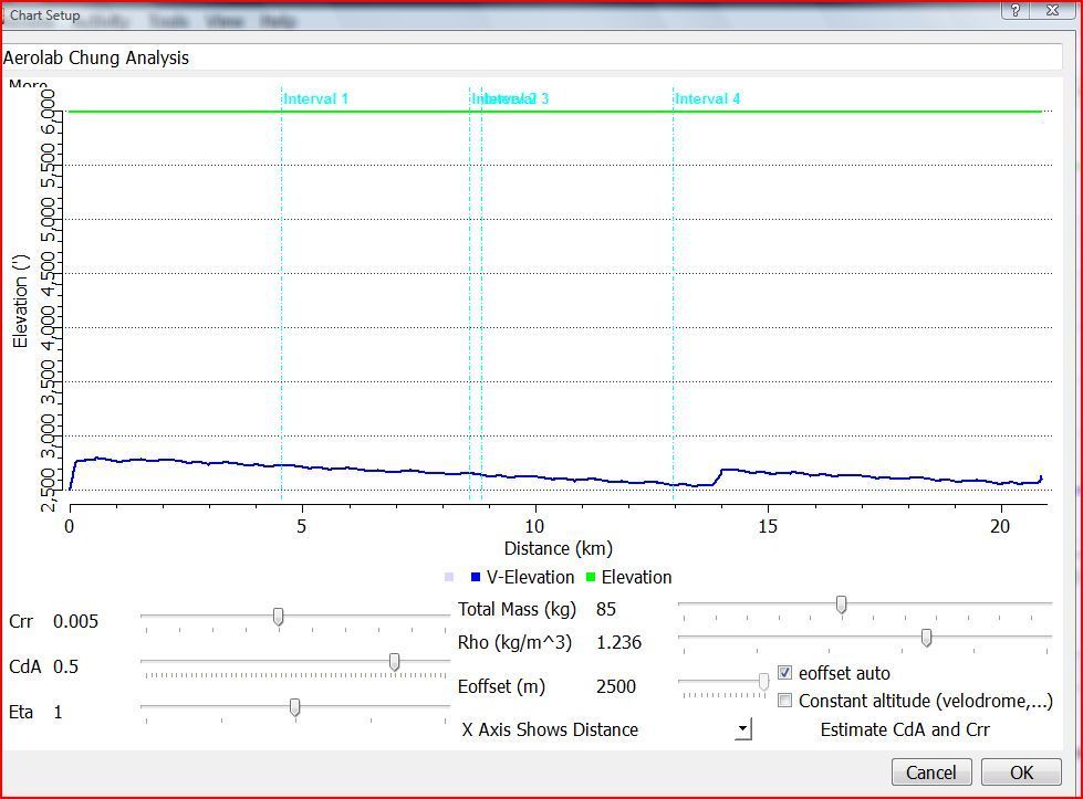
I am having an elevation problem with Aerolab. The runs I am doing are at 6,000 feet and the elevation line show that but the VE line is at 2,800 feet. What this is doing is making the graph have too large of an elevation range, as a result the 80 feet hills that I am climbing on my laps can not be seen, the VE line looks flat. Is there a way to get the VE line closer to the actual evaluation so I can match up the hills. Below is a chart where I did like 12 loops as you see none are discernible using the CdA slider.

[URL=http://s48.photobucket.com/...dia/aerolab.jpg.html][/url]

BoulderCyclingCoach.com
Quote Reply
Re: Platypus Thread: Aero Virtual Elevation Testing Protocol [rockdude] [ In reply to ]
Quote | Reply
Have you tried unchecking the "eoffset auto" box and using the slider to set the elevation offset?
Quote Reply
Re: Platypus Thread: Aero Virtual Elevation Testing Protocol [rockdude] [ In reply to ]
Quote | Reply
You might also just clear all the elevation data from your ride. I've found that to help in the past when I had wonky elevation data from my garmin.
Quote Reply
Re: Platypus Thread: Aero Virtual Elevation Testing Protocol [jbank] [ In reply to ]
Quote | Reply
jbank wrote:
You might also just clear all the elevation data from your ride. I've found that to help in the past when I had wonky elevation data from my garmin.

Yeah, sometimes you have to do that. But sometimes unchecking the box and manually setting the elevation offset will work, and sometimes you can scan through the Altitude column in the "Edit" view to see if there are one or two anomalous values and just fix them directly. If there are a whole bunch of bad values, yeah, you might have to clear the entire altitude column.

I wonder whether part of this could be a mismatch between metric and imperial measurements. Rockdude mentioned he rides at 6000 feet, but that Aerolab screenshot looks like the distance is in km and the elevation is in meters.
Last edited by: RChung: Oct 13, 15 8:59
Quote Reply
Re: Platypus Thread: Aero Virtual Elevation Testing Protocol [rockdude] [ In reply to ]
Quote | Reply
Yeah, what jbank said -- clear the elevation. Edit tab, right-click on the altitude column and delete it. Then go back to Aerolab and enjoy. :-)

AndyF
bike geek
Quote Reply
Re: Platypus Thread: Aero Virtual Elevation Testing Protocol [RChung] [ In reply to ]
Quote | Reply
[/quote] I wonder whether part of this could be a mismatch between metric and imperial measurements. Rockdude mentioned he rides at 6000 feet, but that Aerolab screenshot looks like the distance is in km and the elevation is in meters.[/quote]


I think this is the issue. I am pretty sure my altitude data is good. The eoffset auto box does nothing. The elevation line is is pretty close and it shown in feet, The VE line is the line that is off and I think its being shown in meters. I will play around and see if my head unit will record in meters and also try to delete my altitude data. FYI- have had the same issue with two different head units, Joule 2 and the Garmin 910.

BoulderCyclingCoach.com
Last edited by: rockdude: Oct 13, 15 16:15
Quote Reply
Re: Platypus Thread: Aero Virtual Elevation Testing Protocol [rockdude] [ In reply to ]
Quote | Reply
rockdude wrote:
I think this is the issue. [..] The elevation line is is pretty close and it shown in feet, The VE line is the line that is off and I think its being shown in meters.
Yeah, the distance is in Km, the VE line is in meters, but the y-axis is in feet.
Quote Reply
Re: Platypus Thread: Aero Virtual Elevation Testing Protocol [RChung] [ In reply to ]
Quote | Reply
RChung wrote:
rockdude wrote:

I think this is the issue. [..] The elevation line is is pretty close and it shown in feet, The VE line is the line that is off and I think its being shown in meters.

Yeah, the distance is in Km, the VE line is in meters, but the y-axis is in feet.

I deleted the altitude from the files and VE lines now show the hills. I believe I can work with this and start doing some valid testing.
Cheers.

BoulderCyclingCoach.com
Quote Reply
Re: Platypus Thread: Aero Virtual Elevation Testing Protocol [RChung] [ In reply to ]
Quote | Reply
A quick question. I think I've seen the answer around but I can't seem to find it now. Is it ok to stop pedaling for a short period around a corner? I thought I had seen something that mentions you should always try to soft-pedal even when going slow.

I found a decent loop but one of the corners is about 110 degrees and slight down hill. I can do it but if I carry just bit too much speed I can't pedal as I have to lean too much. Sad thing is I banged my nice shiny new P1 pedals yesterday trying it :( Any coasting would be for only about 40 feet per lap of a 0.4 mile loop. I would probably do 3 loops per test.

On minor cool note, I was able to easily notice the difference between riding aero versus on the bars when I plugged into Aero Lab in a quick test "proof of concept" test. I know that may not easily apply to minor changes but I just wanted to make sure I could at least make some sense of the data doing something very simple.
Quote Reply
Re: Platypus Thread: Aero Virtual Elevation Testing Protocol [Burhed] [ In reply to ]
Quote | Reply
I had found issues with my quarq when I didn't soft pedal. The problem I had was that the quarq would keep registering the last power for a while if it didn't see the magnet tripped by an extra crank rotation. So in particular if you went fairly hard and suddenly stopped pedaling you could get weird results. If you aren't using a quarq (and maybe with new firmware this is fixed as well) I wouldn't worry. If you are using a quarq, at least try to make sure there is no big change where you suddenly go from high power to not pedaling.
Quote Reply
Re: Platypus Thread: Aero Virtual Elevation Testing Protocol [Burhed] [ In reply to ]
Quote | Reply
Burhed wrote:
A quick question. I think I've seen the answer around but I can't seem to find it now. Is it ok to stop pedaling for a short period around a corner? I thought I had seen something that mentions you should always try to soft-pedal even when going slow.

The physics doesn't care if you are pedalling or not, it's really only braking that's the problem as there is no allowance made for it in the equations. So theoretically there is no problem.

However....

The issue with not pedalling is how your power meter and head unit combination reports power when you stop and restart pedalling. Examine the power file closely around the points where you stop pedalling and restart pedalling. How accurate is the power data at those times? In some cases it is fiction, and as a result it can introduce an error as the data departs from reality.

Whether it's an error of consequence depends on how bad the data is, how often the error occurs/accumulates, how fine a difference you are attempting to parse out of the data.

http://www.cyclecoach.com
http://www.aerocoach.com.au
Quote Reply
Re: Platypus Thread: Aero Virtual Elevation Testing Protocol [AlexS] [ In reply to ]
Quote | Reply
AlexS wrote:
Burhed wrote:
A quick question. I think I've seen the answer around but I can't seem to find it now. Is it ok to stop pedaling for a short period around a corner? I thought I had seen something that mentions you should always try to soft-pedal even when going slow.


The physics doesn't care if you are pedalling or not, it's really only braking that's the problem as there is no allowance made for it in the equations. So theoretically there is no problem.

However....

The issue with not pedalling is how your power meter and head unit combination reports power when you stop and restart pedalling. Examine the power file closely around the points where you stop pedalling and restart pedalling. How accurate is the power data at those times? In some cases it is fiction, and as a result it can introduce an error as the data departs from reality.

Whether it's an error of consequence depends on how bad the data is, how often the error occurs/accumulates, how fine a difference you are attempting to parse out of the data.

Right, the issue is that some power meters (and head units) don't handle sudden stops and starts all that well. If you're doing a test that lasts, say, 3 or 4 minutes and you lose 3 seconds because your power meter doesn't handle starts and stops well that's probably not a big deal. If your test is only 30 seconds long it could be. So you look at your data to see if your power meter and head unit is susceptible to this or not. If so, make sure you don't do 30 second long tests.

(There's a secondary issue that your CdA can vary a tiny bit if you're coasting with your legs at 9 o'clock and 3 o'clock vs. if your legs are at 12 o'clock and 6 o'clock. I can never remember to be consistent with that so I soft-pedal even when I'm coasting so I don't have to remember).
Quote Reply
Re: Platypus Thread: Aero Virtual Elevation Testing Protocol [RChung] [ In reply to ]
Quote | Reply
Hi.
Some excellent information in here.
I have just started playing with Aerolab and today attempted to follow the process and get an estimate of my cda and to see if there is difference between 2 front wheels.
So I did 2 runs - one of 5 laps ( up and back) with frt wheel 1 and one of 6 laps ( because one turn was ruined waiting for traffic and I had to over run the turn point) with frt wheel 2.
The results are confusing however. Firstly my cda number is way bigger than I would have imagined ( around 0.31 - this is with full TT kit) and secondly the VE on run 2 is all over the place for the first 2 laps then ok (ish) for the next 4. So I am wondering if I have made a serious error in my inputs or if the course is just not suitable for purpose.

The course I used is a bit over 3km each way with slight rises at the turn points to allow me to coast to the turn point with nil or very minimal braking to turn. It is a pretty flat course and I rode it at a fairly steady power output around 150 but often lower - (today is a recovery day for me).

I used a Garmin 510 and stages power meter. I used GPS for speed ( I have read that this can be problematic).


This is run 1:

[URL=http://s935.photobucket.com/...zpsoxzeowpk.png.html][/url]

This is run 2:

[URL=http://s935.photobucket.com/...zpsitygvujw.png.html][/url]


Given all of the above...is this data sufficient for (any) purpose?

thanks
Lindsay
Quote Reply
Re: Platypus Thread: Aero Virtual Elevation Testing Protocol [Linds] [ In reply to ]
Quote | Reply
No idea what went wrong on run 2. Is there any chance of brake rub? Also, what in the heck is the green elevation line?

I would start by making sure your equipment is working correctly. You need a real speed sensor (GPS isn't accurate enough) and you should turn the GPS function off. At 3k your course is kinda long. do you really have 3k of consistent pavement and no traffic? I would also start testing something like a road helmet versus an aero helmet. You need to be pretty good at this before you can test for minor differences like front wheels.
Quote Reply
Re: Platypus Thread: Aero Virtual Elevation Testing Protocol [grumpier.mike] [ In reply to ]
Quote | Reply
grumpier.mike wrote:
No idea what went wrong on run 2. Is there any chance of brake rub? Also, what in the heck is the green elevation line?

I would start by making sure your equipment is working correctly. You need a real speed sensor (GPS isn't accurate enough) and you should turn the GPS function off. At 3k your course is kinda long. do you really have 3k of consistent pavement and no traffic? I would also start testing something like a road helmet versus an aero helmet. You need to be pretty good at this before you can test for minor differences like front wheels.


Thanks Mike
No, no sign of brake rubbing.
Yes the 3km w/out traffic is no problem early in the morning on this road and it is a very nice surface.
But I can find a shorter run somewhere if required.

The Garmin 510 elevation is clunky isnt it...it seems overly eratic but it is a very flat course..and how sensitive to actual elevation is this protocol?
I thought I read in here somewhere that the 510 had better GPS data ( than the 500) that made it acceptable for this test? If not, I do have the speed sensor I can put on.

I do hope I have dodgy data..because 0.31 is much worse than expected.
Last edited by: Linds: Nov 29, 15 21:36
Quote Reply
Re: Platypus Thread: Aero Virtual Elevation Testing Protocol [Linds] [ In reply to ]
Quote | Reply
What power meter were you using? Did you send the power meter 3 consecutive "zeros"? Were the offsets all the same?

I've been incorporating a 3-zero protocol lately for the power meters we use when aero testing. It's surprising how often the first zero sent to almost any power meter will be different than the subsequent ones. Try and see.

That may be the source of many aero "puzzles", btw.

AndyF
bike geek
Quote Reply

Prev Next