Login required to started new threads

Login required to post replies

Prev Next
Re: Platypus Thread: Aero Virtual Elevation Testing Protocol [sna_b] [ In reply to ]
Quote | Reply
sna_b wrote:
I’m in the midst of trying to hone in on using Aerolab properly. I’ve read the string a few times and studied the PDF doc as well that explains Chung’s Aero testing and VE. I’ll try to keep it short; here’s what I’ve done:
· Testing TT position, standard hold on extensions to find a baseline cda#
· Terrain – outdoor industrial park that has no stop signs and limited to no traffic on weekends
· Winds very light but increase throughout the day
· Used some apps to retrieve data on humidity, temp, Rho, Air density, etc
· Rode 3 loops on a .9mile loop (egg shaped) and started lap 1 at 250W, lap 2 at 270 and lap 3 at 290, essentially 1 shift harder per lap….i wasn’t shooting for specific power targets but they came out close to this
· Garmin 500 capturing data at 1sec intervals and speed sensor is connected and Quarq PM is calibrated prior to each run

Just to be absolutely sure here: is the GPS on your Garmin 500 really off? That's the only way you'll be able to make use of the speed sensor, I think. And GPS speed is notoriously crappy.

AndyF
bike geek
Quote Reply
Re: Platypus Thread: Aero Virtual Elevation Testing Protocol [AndyF] [ In reply to ]
Quote | Reply
Hi Andy- the Garmin GPS was 'ON'. I enabled the speedsensor, but It sounds like i need to disable the GPS and that might tighten things up.
Quote Reply
Re: Platypus Thread: Aero Virtual Elevation Testing Protocol [sna_b] [ In reply to ]
Quote | Reply
sna_b wrote:
Hi Andy- the Garmin GPS was 'ON'. I enabled the speedsensor, but It sounds like i need to disable the GPS and that might tighten things up.

I think so. Garmin doesn't make it very easy to turn the GPS off permanently, unfortunately, so you have to do it every time. And then make sure the Edge 500 is properly paired with the speed sensor.

RChung, is it possible that the poor data consistency between VE and E is attributable to crummy GPS speed?

AndyF
bike geek
Quote Reply
Re: Platypus Thread: Aero Virtual Elevation Testing Protocol [sna_b] [ In reply to ]
Quote | Reply
sna_b wrote:
Good catch, I definitely did not climb that much. This loop does have a false flat but nothing close to a climb. I do have an old file (same loop, more laps) i pulled from the 500 and directly put into GC, it looks better...but i'd love to hear what your expert eye sees.
Ah, yes, that looks more reasonable. OK, I'm thinking that passing it through an "altitude correction" caused the problem. You may still be able to upload to TP and then on to GC (though I prefer to go directly to GC) but don't do that altitude correction thing. It's also possible that some of that is due to GPS speed rather than a wheel speed sensor, but a large part of it seems like that altitude correction wasn't correcting right.

Quote:
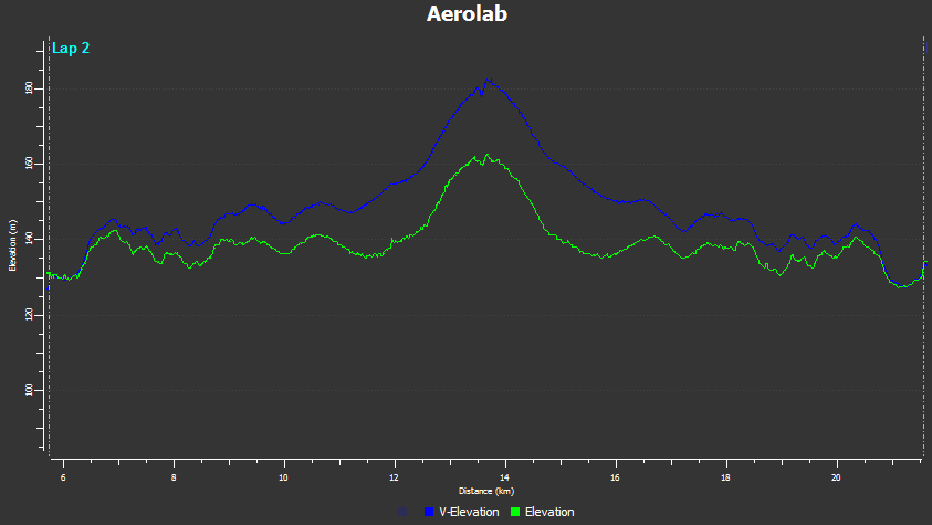
The 2 shots below are the same loop just with "constant alt" checked and unchecked. So, if i was using this file, would i match up the VE with the V and level the start/finish points of the VE to give me the cda#? does the .2453 look correct?

I only use the "constant altitude" checkbox when I know it's absolutely constant altitude, like on a velodrome. Otherwise, I leave it unchecked.

I think .24 is probably in the right ballpark, though the exact CdA will depend on getting the exact Crr correct. There are protocols you can use that might make it easier to "pry apart" the CdA and Crr, but they require that you really do have everything else carefully measured (for example, you want to make sure you have a separate speed sensor and aren't using GPS for speed, and you'll want to make sure you're using the correct wheel diameter, etc.). For now, I'd suggest just getting some experience with the data collection, and after a few trips out to the industrial park you'll have a much better idea of how sensitive the method is and how careful you need to be in collecting data. I found out that I need to hit the corners at the same spot each lap, so I sometimes use a little piece of chalk to mark X's at the "entrance" and "exit" for turns. I vary the speed at different points around the laps (including coasting sometimes), and I toss the first run of the day (as I mentioned somewhere in the thread up above). I used to use a little 3x5 index card with a checklist of things to do for the tests (like, check the tire pressure and zero the torque and so on) but now I use my phone to take a photo of my setup and to make little voice notes on the runs. These are some of the little tricks I've come up with over time. If you come up with others, please post them to this thread.

I should mention that since you're using a Quarq, you should set your eta slightly below 1.0 (maybe .97 or so -- that means 3% loss in the drivetrain). You only have eta set at 1 if you're using a PT.
Last edited by: RChung: Jan 1, 15 9:30
Quote Reply
Re: Platypus Thread: Aero Virtual Elevation Testing Protocol [RChung] [ In reply to ]
Quote | Reply
Very helpful insight. i'll keep collecting data to fine tune. Much appreciated! HNY
Quote Reply
Re: Platypus Thread: Aero Virtual Elevation Testing Protocol [sna_b] [ In reply to ]
Quote | Reply
Happy new year to you, too. Keep us informed.

The moral of the story thus far: GPS elevation and speed isn't good enough for this purpose.
Quote Reply
Re: Platypus Thread: Aero Virtual Elevation Testing Protocol [AndyF] [ In reply to ]
Quote | Reply
Wait--I have an edge 500--I thought that once you hard-code the rolling circumference of the tire (on a powertap) it will use that as its distance/speed measure rather than GPS (while simultaneously logging gps coordinates). Doing so has eliminated the "speed/distance" bounce you get with the Garmin when you're sitting still.

The question of who is right and who is wrong has seemed to me always too small to be worth a moment's thought, while the question of what is right and what is wrong has seemed all-important.

-Albert J. Nock
Quote Reply
Re: Platypus Thread: Aero Virtual Elevation Testing Protocol [Derf] [ In reply to ]
Quote | Reply
Derf wrote:
Wait--I have an edge 500--I thought that once you hard-code the rolling circumference of the tire (on a powertap) it will use that as its distance/speed measure rather than GPS (while simultaneously logging gps coordinates). Doing so has eliminated the "speed/distance" bounce you get with the Garmin when you're sitting still.

Ok, perhaps my bad here. I can remember that I have been bitten in the butt by GPS speed on an Edge 500 before, though.

AndyF
bike geek
Quote Reply
Re: Platypus Thread: Aero Virtual Elevation Testing Protocol [AndyF] [ In reply to ]
Quote | Reply
I don't want to insinuate that I'm correct either. I thought that was the case, but now I'm doubting my previous confidence in this matter.

I know for a fact that you're correct when you use the "auto-circumference" mode, just not sure when you hard-code that value.

Edit: everything I'm reading says that (at least the Edge 500) will prioritize Speed = Powertap rotations * circumference over GPS.

The question of who is right and who is wrong has seemed to me always too small to be worth a moment's thought, while the question of what is right and what is wrong has seemed all-important.

-Albert J. Nock
Last edited by: Derf: Jan 1, 15 13:26
Quote Reply
Re: Platypus Thread: Aero Virtual Elevation Testing Protocol [Derf] [ In reply to ]
Quote | Reply
Yeah, DCRainmaker has this in one of his reviews (for the new Garmin speed sensor).

Here's the overview of order of preference for GPS units:


Cadence:
1. Power meter sending torque and cadence (e.g. Vector, SRM, Quarq)
2. Cadence sensor
3. Power meter sending power values and cadence (e.g. Power2Max, Rotor)


Speed:
1. Power meter sending torque and speed (e.g. PowerTap). In this case wheel speed is needed to compute power.
2. Speed sensor
3. GPS
Quote Reply
Re: Platypus Thread: Aero Virtual Elevation Testing Protocol [Zenmaster28] [ In reply to ]
Quote | Reply
Thanks!

The question of who is right and who is wrong has seemed to me always too small to be worth a moment's thought, while the question of what is right and what is wrong has seemed all-important.

-Albert J. Nock
Quote Reply
Re: Platypus Thread: Aero Virtual Elevation Testing Protocol [RChung] [ In reply to ]
Quote | Reply
RChung wrote:
The moral of the story thus far: GPS elevation and speed isn't good enough for this purpose.

OK, in my admittedly limited understanding, while clearly speed accuracy is very important, is the robustness of the actual elevation that important to VE testing if you're just trying to compare different setups and not trying to pry apart exact Crr? It's my understanding I'm trying to level the VE trace rather than match it to the actual elevation trace. In my case I've been using barometric elevation but it's a bit flakey on my Garmin and not necessarily much better than GPS altitude.

Thanks for developing such a cool tool, BTW.
Quote Reply
Re: Platypus Thread: Aero Virtual Elevation Testing Protocol [tttiltheend] [ In reply to ]
Quote | Reply
tttiltheend wrote:
RChung wrote:
The moral of the story thus far: GPS elevation and speed isn't good enough for this purpose.


OK, in my admittedly limited understanding, while clearly speed accuracy is very important, is the robustness of the actual elevation that important to VE testing if you're just trying to compare different setups and not trying to pry apart exact Crr? It's my understanding I'm trying to level the VE trace rather than match it to the actual elevation trace. In my case I've been using barometric elevation but it's a bit flakey on my Garmin and not necessarily much better than GPS altitude.

Thanks for developing such a cool tool, BTW.

No, you're right. The actual elevation doesn't matter much -- except when you get fooled into thinking that it's accurate when it's not. Then you can end up chasing rainbows, trying to match up to something that's wrong. If it's right (and you know it's right) then it can help you identify the Crr and CdA exactly.

And you have to thank Andy F. and the GC guys for developing Aerolab.
Quote Reply
Re: Platypus Thread: Aero Virtual Elevation Testing Protocol [RChung] [ In reply to ]
Quote | Reply
Thanks for clarifying.

Fixed my post: Thanks for developing such a cool concept and to Andy and the GC team for developing the aerolab tool.
Quote Reply
Re: Platypus Thread: Aero Virtual Elevation Testing Protocol [AndyF] [ In reply to ]
Quote | Reply
AndyF wrote:
Ok, perhaps my bad here. I can remember that I have been bitten in the butt by GPS speed on an Edge 500 before, though.
The Edge 500's GPS reception can be pretty bad. Whenever I've offered to aerolab someone's TT for them, and they've sent me a file from an Edge 500, I've always thought "never again" after having to go through the whole file by hand fixing all the issues with the speed data.

OTOH The Edge 1000 produces pretty nice data (GPS+GLONASS), e.g. a 10 mile TT I rode with headwind out / tailwind back without a speed sensor:


I haven't used a speed sensor since getting the Edge 1000, as its GPS+GLONASS speed data seems to be very close in quality to speed sensor data, and it has the advantage of not needing to calibrate the rollout.
Quote Reply
Re: Platypus Thread: Aero Virtual Elevation Testing Protocol [Steve Irwin] [ In reply to ]
Quote | Reply
Steve Irwin wrote:
OTOH The Edge 1000 produces pretty nice data (GPS+GLONASS), e.g. a 10 mile TT I rode with headwind out / tailwind back without a speed sensor:


I haven't used a speed sensor since getting the Edge 1000, as its GPS+GLONASS speed data seems to be very close in quality to speed sensor data, and it has the advantage of not needing to calibrate the rollout.

Woah. That's nice.
Quote Reply
Re: Platypus Thread: Aero Virtual Elevation Testing Protocol [Steve Irwin] [ In reply to ]
Quote | Reply
Quote Reply
Re: Platypus Thread: Aero Virtual Elevation Testing Protocol [Steve Irwin] [ In reply to ]
Quote | Reply
Doesnt the 510 use the same system?
Quote Reply
Re: Platypus Thread: Aero Virtual Elevation Testing Protocol [neilridley] [ In reply to ]
Quote | Reply
yes
Quote Reply
Re: Platypus Thread: Aero Virtual Elevation Testing Protocol [neilridley] [ In reply to ]
Quote | Reply
The 510 also has GLONASS. I haven't used a 510, but my experience with 705, 500 and 800 before the 1000 is that the larger devices tend to have better GPS reception. A clubmate once told me he did a calculation of the optimal antenna size for a GPS signal, and found it to be a bit larger than any of the Garmin cycling devices, so the larger devices would be closer to the optimal antenna size if his calculation was correct.
Quote Reply
Re: Platypus Thread: Aero Virtual Elevation Testing Protocol [Steve Irwin] [ In reply to ]
Quote | Reply
Steve do you a weather station to collect data or pick it up later from the web? Seen a few apps on itunes that are supposed to pick up the airdensity from your nearest station . Being stuck on an island stuck in the english channel im really struggling to find a suitable test circuit, ( small island so no big industrial estates or carparks and windy!)
Quote Reply
Re: Platypus Thread: Aero Virtual Elevation Testing Protocol [neilridley] [ In reply to ]
Quote | Reply
Air pressure from airport weather data, temperature from airport weather data combined with Garmin data.
Quote Reply
Re: Platypus Thread: Aero Virtual Elevation Testing Protocol [Steve Irwin] [ In reply to ]
Quote | Reply
do you use sea level air pressure or correct it for the height of the test circuit?
Quote Reply
Re: Platypus Thread: Aero Virtual Elevation Testing Protocol [neilridley] [ In reply to ]
Quote | Reply
I've never tested anywhere that isn't essentially at sea level. But looking at an example of a TT course I ride, the highest elevation is 40m above the lowest elevation, and if the mean elevation were 20m above sea level, perhaps I should be accounting for the 0.26% reduction in pressure. It doesn't really matter, because I never compare CdA values across different courses or test venues anyway, as there are other reasons why they won't be comparable, e.g. unknown differences in Crr due to different surfaces. So as I'm only comparing against CdA for other rides on the same course, a constant adjustment for the course always being a certain amount above sea level would make no difference, the main concern is to correct for the air pressure difference between the two rides.
Quote Reply
Re: Platypus Thread: Aero Virtual Elevation Testing Protocol [neilridley] [ In reply to ]
Quote | Reply
If you're getting air pressure from an official weather station it's usually standardized to sea level. If you're getting air pressure from a local source it can sometimes be "station pressure" so it's not.

If you're on an island in the Channel you probably don't have to worry too much about the difference.
Quote Reply

Prev Next