No. I imagine that there is at least some truth to the rumored new course, but its just a tough pill to swallow 30 days out to increase the elevation that much.
I’ve got to believe that they are trying to find a suitable course that isnt that drastic of a change, but what do I know.
As someone’s signature line in here says…of course its hard, its f#@*ing ironman.
Personally, I will be proud to have completed this tough bike run combo. (so hopefully i do finish it)
The rumored highway course has 8K of elevation gain which is about double the original course.
My only concerns are:
Tri bike or road bike?
Descending fast on a 3 loop course around people who dont know how to descend fast and/or hold a line.
I saw same, but don’t believe the elevation data is correct. To use a technical term, it looked ‘wonky’, and also I think it’d be exceptionally rare for a freeway to have 14% gradients scattered about, no matter how short. I agree that a three loop bike course in a sold out race will create some dangerous situations and more crashes. Though the second loop of the original course with the BOP athletes and people driving on the roads was also pretty sketchy.
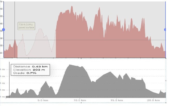
I can see that the gradience on the Strava map differs from the youtube.
Strave has ~6% steady on the first big climb. Youtube has 14% at some spots.
The difference for this 25mile section is about 200ft less on the strava.
I can see that the gradience on the Strava map differs from the youtube.
Strave has ~6% steady on the first big climb. Youtube has 14% at some spots.
The difference for this 25mile section is about 200ft less on the strava.
See this sreenshot:
Someone on Facebook posted the Strava segment from the Waterfront triathlon and it looks a lot less aggressive:
This one doesn’t go all the way to Soddy-Daisy so it’s not got that additional elevation on the end of the loop, but there’s no 14% gradient at the start either.
For the 2024 edition of First Horizon Bank IRONMAN Chattanooga, part of the VinFast IRONMAN North America Series, we are excited to unveil a new bike course. Athletes will experience more of Southeastern Tennessee than ever before while on their 140.6-mile IRONMAN journey throughout the region.
Once out of the water, athletes will exit transition on Riverfront Parkway and head south to Martin Luther King Boulevard and on to US-27. Athletes will then head north through Red Bank and up to Soddy Daisy. Athletes will complete three loops on US-27 before heading back toward Chattanooga.
The new bike course will offer a dedicated lane throughout the entire course, with great views and fresh pavement as athletes parallel the Cumberland Plateau during the ride. The new course will consist of 4,300 feet of elevation gain across 112-miles.
Is it really 4300 ft of climb? Several people say it’s somewhere between 6000 and 8000. Can any locals confirm???
Not a local and can’t confirm anything, but I did have a friend build the route in google maps and get 3700ft. Same friend said he saw or read or was told that the road was recently paved. I’m personally anticipating a rolling but fast course.
Not a local either, I did a similar virtual ride on Strava and it came out to a little over 4000ft.
There are over 20 climbs, most of them small, but some are big and there are 5 u-turns.
We will need to get out of our aero position a lot, so double check the shifting and consider putting some bar tape on the basebar bull horns.
I could see there being 14% grade on that course. Highway 27 bridge that goes over the Tennessee river is long and has a steep grade. After that bridge it shouldn’t be too bad. My concern is what lanes are they closing for the course. Glad I’m not racing. lol
ride with GPS gave me 2200ft per loop (roughly 34 miles per loop) but hard to say how accurate it is. I never trust IM elevation on the bike map. They say IMWI is 4200 ft and its actually closer to 5600 +/-
When we were doing our final checks and GPSing this one, the steepest part was 7.3% on the 260ish feet of vertical climb at mile 4. Nothing close to 14%. I have 560 feet in the first 5 miles to get to the loop, 1110 per lap (x3) and then 236 on the return from the loop in the last five miles. Mapmyride, ride with GPS, Strava, Garmin are all over the place when you enter them into a computer. We spent a lot of time on the course coming up with the most realistic number we could. That being said, the only number that seems to matter to athletes is the number on their garmin or device.
When we were doing our final checks and GPSing this one, the steepest part was 7.3% on the 260ish feet of vertical climb at mile 4. Nothing close to 14%. I have 560 feet in the first 5 miles to get to the loop, 1110 per lap (x3) and then 236 on the return from the loop in the last five miles. Mapmyride, ride with GPS, Strava, Garmin are all over the place when you enter them into a computer. We spent a lot of time on the course coming up with the most realistic number we could. That being said, the only number that seems to matter to athletes is the number on their garmin or device.
Brian
^^^^^
This should put the discussion to bed.
Thank you!
Don’t worry. I’m sure someone will be along soon enough to argue with the actual RD of the race as to why his numbers are off and it’s really 8,000’.