Looking for some guidance / suggestions / confirmations.
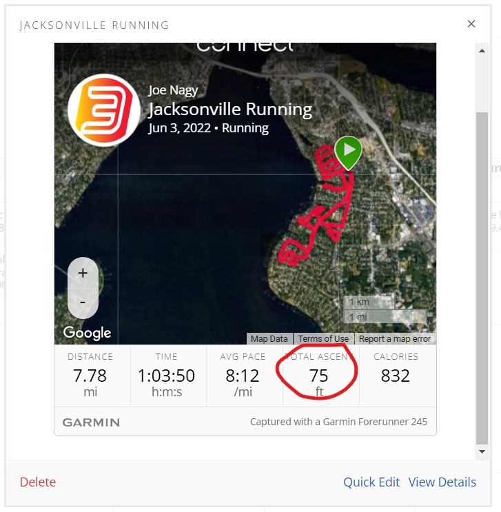
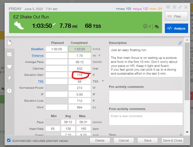
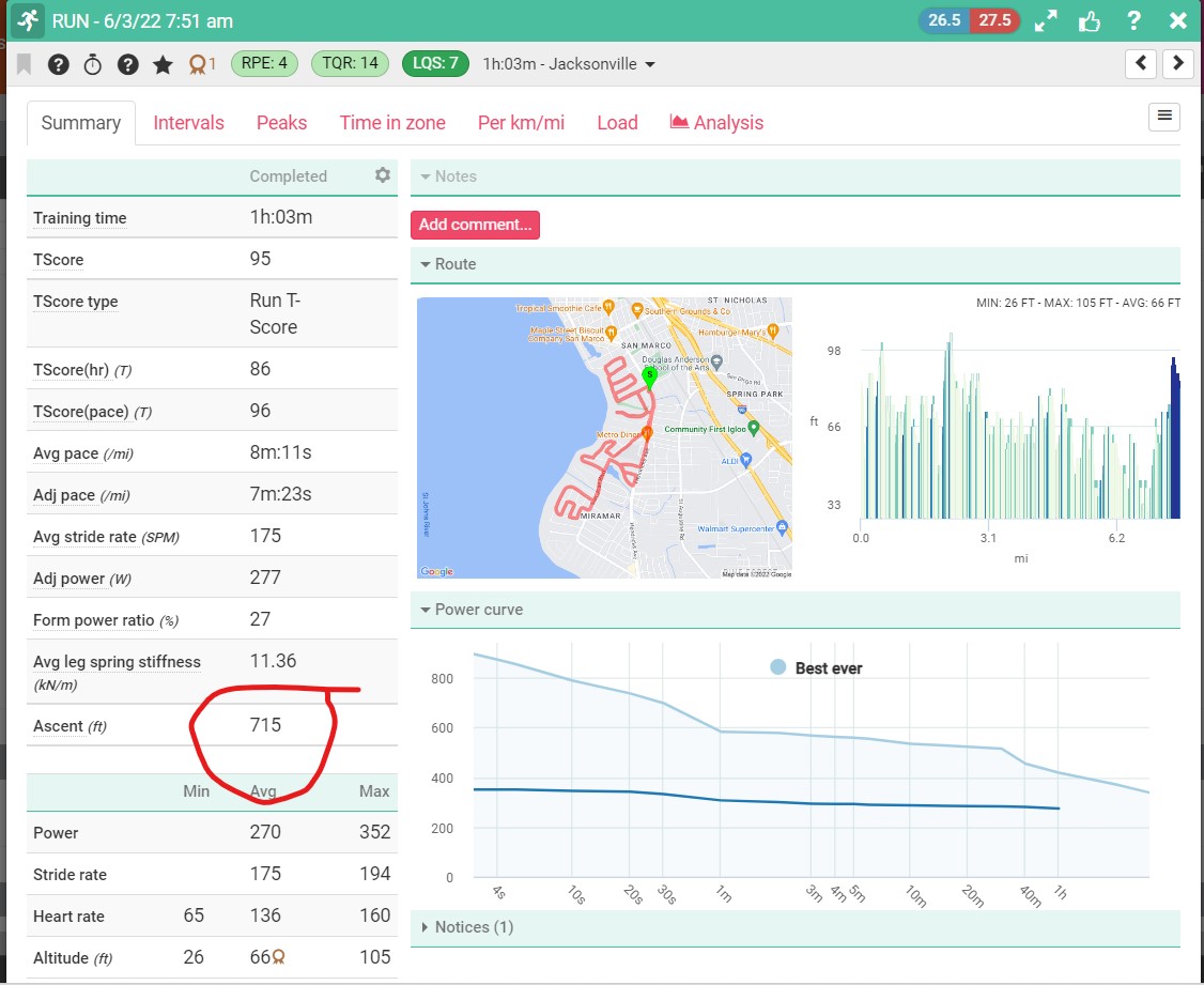
I do a run in Jacksonville FL (flat). Connect shows 75’ elevation gain. Sounds plausible - I am using the 245 so no barometer. That same workout in both Training Peaks and Today’s Plan shows over 700’ gain. All the other data matches - they’re all reading from the same .FIT file…
I’ve emailed support of all three companies - I think its odd that two different companies both report same inaccurate elevation where Garmin shows it correctly. Does this point to being a Garmin issue?
Curious if anyone else has noticed the discrepancy between 3rd party platforms and Garmin Connect.
Garmin is recording inaccurate elevation data and applying elevation correction in Garmin Connect based on GPS. Open the workout/file in Garmin Connect, under your device you will see it says: elevation correction - enabled. If you disable this it should show the elevation data that Garmin is recording in the file and sending to the other platforms.
Gotcha - so raw data is garbage and Garmin knows as much so it automatically overwrites it.
So what is my watch even recording for elevation (rhetorical)? If it’s recording GPS then isn’t the data already in the FIT file? This post process correction seems like Garmin should be doing that within the watch before sending out (or say I looked at my watch without using Connect - which I should check out next time at end before uploading)
Basically you get garbage data from broken barometers or garbage data using GPS - what’s the point? Guess lesson learned - I went with 245 as I am done with broken barometers on high end watches. Thought this would be better but not really it seems. What am I paying for if I have to auto correct elevation anyways.
Ok rant over…
what are others doing using these watches? Just throwing away any elevation data or auto correcting every workout?
GPS-based elevation is inherently bad. That is why almost all the platforms (Garmin, Strava, etc.) have elevation correction for GPS-based elevation. Barometer-based elevation is pretty good. Until it isn’t. Hopefully Garmin figured it out in their watches and it will be better going forward. (They are currently experimenting with disabling the thermometer during swims, because they believe the active thermometer may be killing the barometer when the combo-sensor is wet.)
the barometer on my 520 hasn’t worked well for years and it constantly under-reports elevation gain. Most of the time i just ignore it…but sometimes i do use autocorrect in Garmin connect. Would be ideal if there was the option to auto correct in real time …or even automatically apply the autocorrect when uploading to Connect.
I havent had issues with bike computers and dont think it impacts data but the run stuff really gets screwy with NGP and IF and stress scores (I have noticed this even when using a stryd power meter)
Does trainingpeaks have an auto elevation feature like connect is doing? Hmm… That would be nice. Also be nice if i could auto correct from app, not needing to go to computer to do it later.
I would rather take no data over data i constantly need to correct.
Funny and shame on me tho - I bought this watch specifically because I was so frustrated with my broken barometer on my fenix and wanted something that wouldn’t need constant correction…
Since your watch doesn’t have a barometer, Garmin determines elevation via GPS triangulation. This is the raw data and, it’s not necessarily incorrect. When one enables “elevation correction”, then elevation is determined from topo maps from the longitude and latitude position. I don’t think Garmin sends third parties the raw elevation data determined from GPS triangulation, but instead merely sends longitude and latitude position. The third parties then use this data and topo map data. Since there are a number of topo maps out there, errors can be large especially in hilly or mountainous terrain. In addition, algorithms are necessary to dither the data to increase the reporting accuracy. RideWGPS put a great deal of effort into this in order to report elevation as best they could. Other third party outfits probably put little effort into this, and merely do something simple with the longitude and latitude data Garmin makes available to them.
With a barometer in a Garmin watch, or any of their cycling computers, Garmin will correct the internal barometer about every 15 minutes or so via elevation triangulation from the GPS signals. This avoids potentially large inaccuracies from pressure and temperature changes while using the computer or watch.
Except I live in Jacksonville- from 0 ft to 32ft MAX above sea level. So how is it these platforms are getting hundreds of feet in elevation using ANY lat/long ANYWHERE close to where I’m running.
I get the accuracy of GPS on a hillside where 2-3ft might drastically change elevation. No case on these runs.
I get how barometers work - they just don’t ultimately. Then I’m running with 13,000’ elevation gain!
Basically shame on me for thinking I was going to get anything accurate and no one else out there has the magic solution - just manually auto correct elevation after every run.
Hey at least the watch was cheaper… because that was the same thing I was doing on my Fenix with it’s busted altimeter.
Because those third party apps are junk. They don’t put forth the effort, time and money to publish accurate elevation data. The good topo map outfits charge for the use of their data. Those third party outfits don’t want to spend money, they are trying to sell advertising. In other words, it’s not a priority for them. They probably calculate elevation by the old technique of, pulling it out of their ass.
Garmin smooths their data from their devices employing an electronic barometer because otherwise, noise would be making elevation jump 1 or 2 feet every time it sampled, and when added up and calculated for gain you might end up with 715’. I’m not sure exactly what data and format Garmin sends to third party outfits.
So I’m probably not helping much now. If I were you, I’d get the new 255 watch and I believe you will get consistent and reasonably accurate information. And you should not need to set GC for elevation correction.