For the geek in me. Does any one know the elevation for the Big Kahuna bike portion? The website doesn’t mention it. I figure it’s around 2k as a guess.
Thanks,
Mark
For the geek in me. Does any one know the elevation for the Big Kahuna bike portion? The website doesn’t mention it. I figure it’s around 2k as a guess.
Thanks,
Mark
.
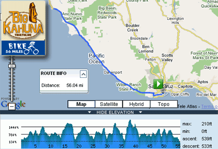
Thank you. Am I reading the chart right? Total elevation only 1078ft?
-Mark
More like total elevation 539 feet. The above chart shows the out-n-back loop. So technically the ascent = descent exactly–but due to slight variations in the mapping technology, it comes out with a 6-ft difference.
Pretty flat to slow-rolling hills.
Thanks for the quick reply. It just seemed hillier on the drive. Once again I managed to psych myself out before a race.
-Mark
Thanks for asking! I was wondering the same thing.
This is from Klimb, a software that maps most the major routes in the Bay Area. It’s missing ~2 miles from around the transition area.
The total climbing should be accurate.

I get 416ft of climb from MapMyRun, following the highway exactly:
Guess I’m outnumbered. 
I did it 4 years ago but really can’t remember it. It was my first half IM and I wasn’t properly trained, so it seemed really difficult.
It is very scenic though. If it’s 400ft, I’m not complaining.